Photogrammetry is revolutionizing the way engineers, architects, contractors, developers, and property owners capture accurate site information. What once required weeks of field measurements and expensive equipment can now be completed in just a few hours using professional drones and advanced software.
At TrueSite360, we provide Ariel Data Collection Services Central Florida services that transform thousands of high-resolution drone photographs into precise 3D models, orthomosaic maps, point clouds, and digital terrain models. These deliverables help clients plan projects more efficiently, reduce costs, improve safety, and make better decisions throughout every stage of construction and property management.
Whether you’re developing commercial property, monitoring construction progress, or documenting existing conditions, photogrammetry provides fast, reliable, and highly accurate data.
What Is Photogrammetry?
Photogrammetry Central Florida is the science of using overlapping photographs to calculate accurate measurements and create realistic three-dimensional models of real-world objects and environments.
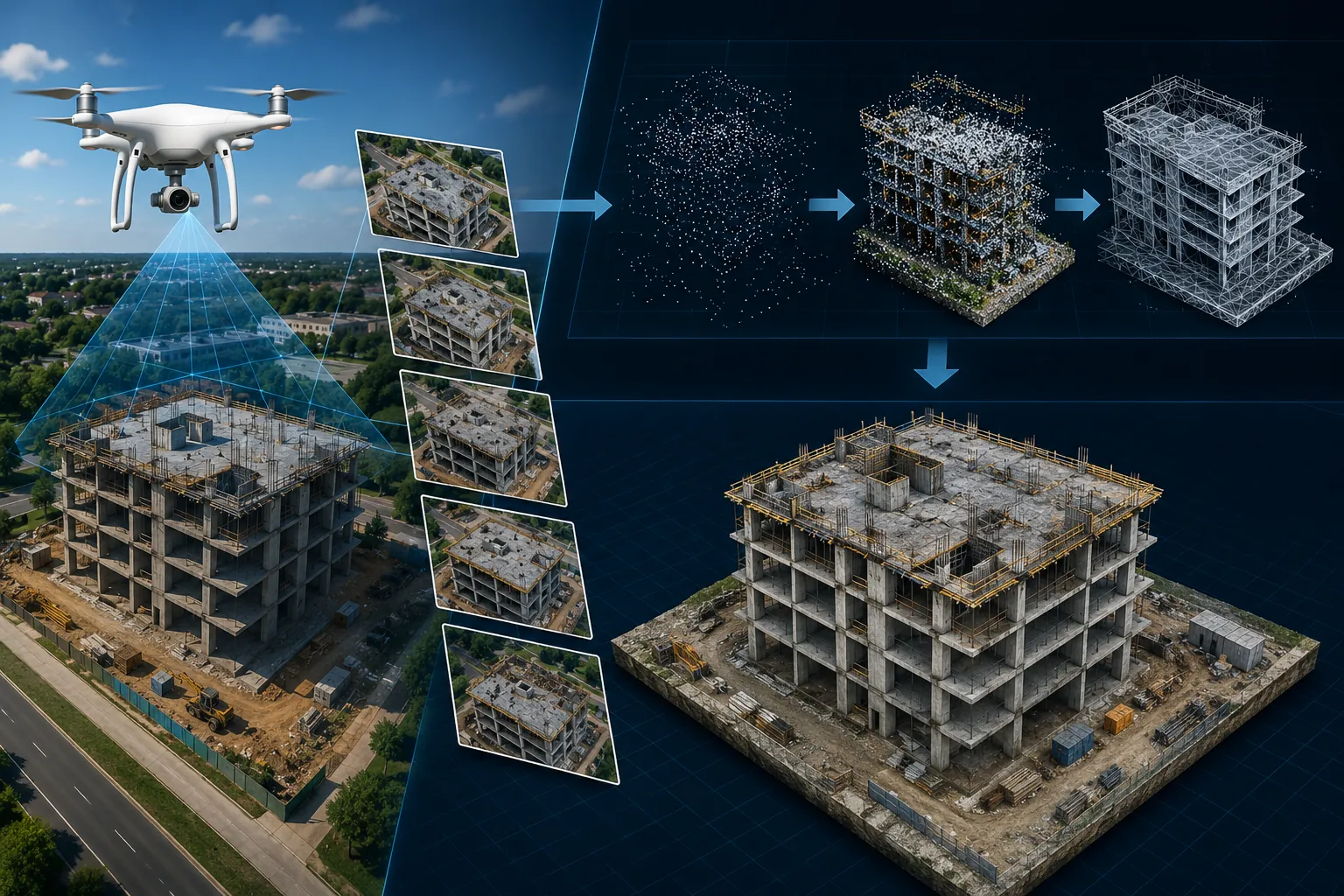
Professional drones fly pre-planned missions over a property while capturing hundreds or even thousands of high-resolution images. Specialized software analyzes the overlap between each photograph and calculates millions of reference points to reconstruct the site in three dimensions.
The result is an accurate digital representation that can be measured, inspected, shared, and used for planning, engineering, construction, and asset management.
How Drone Photogrammetry Works
Professional photogrammetry follows a structured workflow that ensures accurate and consistent results.
1. Flight Planning
Every project begins with careful flight planning. Drone missions are designed to capture the required image overlap, altitude, flight speed, and camera angles needed for accurate reconstruction.
2. Image Collection
The drone captures hundreds or thousands of overlapping high-resolution photographs covering the entire project site.
The greater the overlap between images, the more accurate the final model becomes.
3. Image Processing
Advanced photogrammetry software identifies common points between photographs and calculates their exact positions.
Millions of individual points are combined into an accurate digital representation of the site.
4. Model Generation
Once processing is complete, the collected data can be converted into:
- Interactive 3D Models
- Orthomosaic Maps
- Point Clouds
- Digital Surface Models (DSM)
- Digital Terrain Models (DTM)
- Elevation Maps
- Volume Calculations
- Engineering Deliverables
These products become valuable tools throughout the project lifecycle.
Why Photogrammetry Is Better Than Traditional Survey Methods
Traditional surveying remains important for many projects, but drone photogrammetry offers several major advantages.
Faster Data Collection
Large commercial sites that previously required several days to survey can often be documented within a few hours.
This helps projects move forward without unnecessary delays.
Improve Safety
Drone flights eliminate the need for survey crews to enter hazardous areas, climb structures, or work near active construction equipment.
Keeping personnel safely on the ground significantly reduces workplace risks.
Cost Savings
Because photogrammetry captures large amounts of information quickly, labor costs and equipment requirements are reduced.
Many organizations find that routine aerial surveys quickly pay for themselves through improved efficiency and reduced rework.
Highly Detailed Documentation
Unlike traditional measurements, photogrammetry captures complete visual records of a property that can be revisited long after field work has been completed.
Common Uses for Photogrammetry
Professional Photogrammetry Central Florida services are used across numerous industries.
Common applications include:
- Construction Progress Monitoring
- Topographic Mapping
- Reality Capture
- Digital Twin Creation
- Land Development
- Engineering Surveys
- Building Documentation
- Roof Inspections
- Infrastructure Planning
- Mining Operations
- Utility Corridors
- Municipal Projects
- Environmental Studies
The versatility of photogrammetry makes it one of the most valuable tools available for modern project management.
Photogrammetry for Construction Projects
Construction companies throughout Central Florida use photogrammetry to improve project planning and monitor progress.
Benefits include:
- Accurate site measurements
- Weekly progress documentation
- Earthwork calculations
- Material stockpile measurements
- Better communication with owners
- Reduced project delays
- Improved scheduling
- Faster decision-making
With current aerial data available throughout construction, project managers always have an accurate view of site conditions.
Photogrammetry and Digital Twins
Photogrammetry is also the foundation of modern Digital Twin technology.
The high-resolution models created through photogrammetry become the digital representation of buildings, infrastructure, and facilities.
These Digital Twins allow owners to:
- Inspect assets remotely
- Plan renovations
- Track maintenance
- Improve facility management
- Preserve historical documentation
- Manage infrastructure more efficiently
For many organizations, Digital Twins are becoming an essential part of long-term asset management.
Who Benefits from Photogrammetry?
Professional photogrammetry services benefit:
- Commercial Property Owners
- Construction Companies
- Civil Engineers
- Architects
- Developers
- Municipal Governments
- Utility Companies
- Industrial Facilities
- Mining Operations
- Infrastructure Managers
Whether managing a commercial building or a large transportation project, photogrammetry provides valuable information that supports smarter decisions.
Frequently Asked Questions
What is photogrammetry?
Photogrammetry is the process of creating accurate measurements and 3D models from overlapping drone photographs.
How accurate is drone photogrammetry?
Professional photogrammetry can achieve highly accurate results suitable for engineering, construction planning, mapping, and asset management when proper workflows and ground control are used.
What products can photogrammetry create?
Photogrammetry produces orthomosaic maps, 3D models, point clouds, digital terrain models, elevation maps, and volumetric calculations.
Is photogrammetry suitable for commercial projects?
Yes. Commercial construction, engineering, infrastructure, and real estate projects frequently rely on photogrammetry for planning, documentation, and project monitoring.
Ready to Capture Your Project in 3D?
If you’re looking for an accurate, efficient, and cost-effective way to document your property or construction project, TrueSite360 can help. Our Aerial Data Collection Services Central Florida services provide precise 3D models, detailed mapping, and actionable data that improve planning, reduce costs, and support better project outcomes.
Contact TrueSite360 today to learn how our professional Aerial Data Collection Services services can transform your next project.